Why is it useful to map this data?
Digital collections offer us the opportunity to discover and explore resources that have traditionally had a restricted audience. Maps provide another dimension to the text and photographs that make up this archive and they help us to visualize where Colebourn was during the war. Many of the places he visited were small towns, the locations of which are not common knowledge. We can envision Paris, London and some of the major battle sites of the war, but small towns such as Barlin, Bethune and Nouex Le Mines are much harder to place. Having them located on a map gives us context; we can see places in relation to one another and it allows us to better understand distances travelled.
By mapping the locations of this one man we are able to reconstruct the movements of the Canadian Forces on the Western Front. Colebourn was present working with the horses at the sites of many of the major battles where Canadian Forces fought. As noted on his cigarette case he was at Ypres, Neuve Chapple, Festubert, Somme, Vimy Ridge, Passchendaele, and Lens. Through him we see the movements of a large number of Canadian soldiers during the First World War.
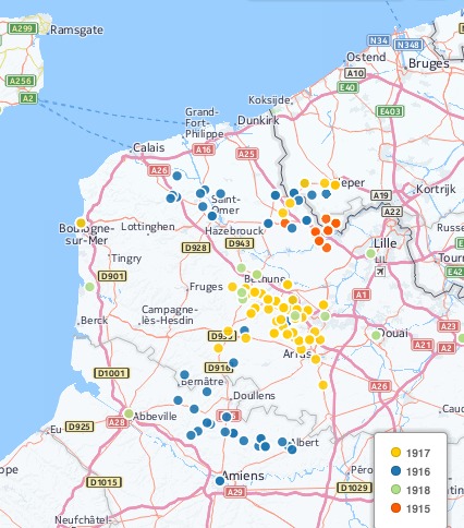
Places visited by Harry Colebourn 1915-1918.
The maps also help us make sense of the variations in names and spellings that occur in the diaries. In many cases Colbourn may have only heard the names and not seen them in print. We have variations such as Au Ritz for Aux Rietz and multiple spellings for some places such as Lucenie, Lusigny and Luscenie. The diaries have been transcribed to be faithful to Colebourn’s spellings, so the maps are a way of collocating these variations in spelling.
Page 3 >